 DAY 6 - August 13, 2010: Feels like homeWoke up refreshed, much better mood than yesterday, in spite of the mosquitoes, which were worse than they’d been below. Vermillion and the trek up from civilization already felt distant. The air was thin and crisp, the water was cold and clear and good-tasting. That stop down there, with the steak and the good breakfast, was a good thing, I guess, but it was distracting, not what I came up here for. Hey, what did I come up here for? Hmmm. Let’s think about that. Or, let’s not, right now. Right now, let’s just get going. Miles to go before I sleep, some beautiful miles ahead.
 This has been one of the sweetest campsites I’ve had this summer, wide, soft ground, large granite stones to sit on. Bear Creek wide, calm, and gorgeous. Wish I could stay and hang out in this area for some days yet, but the schedule won’t let us wait. We’re already going to be a day behind my original plan, because Anniell’s plan calls for staying at Marie Lake tonight, where I’d had us starting two miles ahead of our current position and going all the way to Muir Trail Ranch. No matter, I hear Marie Lake is gorgeous, too. Anniell and I are good hiking buddies, I think it’s made it easier for each of us that the other has been along.
The guys yesterday were right, it was a walk of only another ten or fifteen minutes before we hit the JMT again, and it felt strangely like home. The “10,000 ft – no wood campfires” sign was like an old friend. Back on track with the Whitney countdown. The uphill wasn’t crazy steep, and the trail wasn’t full of sharp rocks jutting out at crazy angles or steps of 2 feet up.
After a few minutes back on the JMT, it starts looking like a hikers’ freeway, a lot more folks than we’d seen before on the trail. I was suddenly passed by a cheerfully young couple carrying silver parasols, what a concept! I guess it was keeping them cool. I was tickled. It was like something out of a Cocteau movie, ever so slightly on the absurd side. But wait! Not two hours later I saw another silver umbrella, coming down from the other direction, and this guy . . . looked like he was wearing a skirt! Then ran into a couple more couples of varying ages, and passed a bunch of young guys taking a long break.Crossing another serious “rock-hopper” of a stream, waited for Anniell to come along, to see if she needed help. Just after she arrived, a group of guys on a fishing trip came marching energetically along, a couple of them with big, big bellies. I guess if you’re under 40 you can have those and still comfortably carry a pack up there . . . had to admire them, because I don’t think I could have! In their company was an older guy, in good shape, as it turned out a retired Army colonel. Anniell was hesitating, having trouble picking out the right spot to cross, but the colonel graciously offered to take her backpack across and let her follow without anything on her back, which they did. When he got over, though, he said aside to me “now that’s what you were supposed to do. They need to be spoiled sometimes.” To this I answered, “I was just encouraging her to be all that she can be.” Not sure if he got the reference. Anyhow everyone crossed safely. And the guys went on past, again marching along at an amazing pace.
Passed the parasol pair taking a break, and we waved to each other. At the next big stream following that I took my own break, filling water bottles and lying back on the grass for a few minutes, during which time the place filled up with people to the point where it was like a hikers’ convention. Anniell was talking to them of the umbrella persuasion, and suddenly the guy came over and introduced himself. “She says you’re a trumpet player. So am I,” he said. Turns out Mark and Julia are from St. Louis, where he freelances on the legit circuit and she plays with the St. Louis Symphony. We compared notes about practice methods, etc., and it was suddenly hard to feel we were way out in the middle of nowhere.
 Wanting more solitude, I waited till everyone had moved on, including Anniell, before starting up again. The two of us arranged to meet where she was planning a lunch break, at Rose Meadow, where the climb up to Marie would start in earnest.
She was still munching and relaxing when I got there. One difference in our hiking styles is that I like to take a lot of short breaks, while she takes fewer and longer ones. So after a few minutes I moved on, and she said great, she’d catch up in a bit.

It actually wasn’t all that long before I pulled up to Marie Lake.  This was a short day, only seven or eight miles, and it was great to get into this beautiful place early and have a chance to rest. And everybody had been right, this was a gem of a place. We were planning on camping at a stream crossing that showed on the map, but we never saw the stream, so we camped up at the southern end of the lake, just before Selden Pass, which we’d go
  over right around sunrise the next day, then on down to our resupply point at Muir Trail Ranch.
Somehow the trip so far just seems like a warm-up. I've been out nearly a week, you'd think it would feel like more than that, no? A warm-up to what? Well, after tomorrow, Anniell's friends will have caught up, that's the plan, and I'll be hiking alone, finding my own pace, probably having more inner conversations than socializing. Also I've already seen everything from Muir Trail Ranch up to Muir Pass, but everything after that—including the next 5 passes, plus Whitney—will be new, and I'll pretty much be committed to finishing the whole thing. Once over Muir Pass there's no easy exit except to just keep on truckin'.Meanwhile, this brief rest at Marie Lake is one more experience among many that are, well, sublime.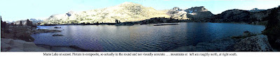 (sorry, you're just gonna have to click on this picture if you wanta really see it . . . )
 DAY 5 - August 12, 2010: a whole day of uphillThe good thing about being at Vermillion this morning was that we didn’t have to move, move, move, get out in a hurry. The bad thing about being at Vermillion that morning was that we didn’t move, move, move, get out in a hurry.This is a resupply point for Anniell. Her group had 4 resupplies: Red’s Meadow, Vermillion, Muir Trail Ranch, and Charlotte Lake. Couldn’t imagine why they needed that many, I only had one, at Muir Trail Ranch, 2 days down the line. But if we were to continue hiking together I’d have to wait for her to finish sorting through her stuff and sending things back to the friend who had opted out at Red’s. This didn’t bother me much at the time, since we didn’t have to scramble like everyone else to make the 9AM ferry back to the JMT cutoff trail at Mono Creek—we’d just march quickly up the Bear Creek Trail and cut off all that useless up and down on the JMT, which didn’t look very scenic anyway. Had a big breakfast, got organized and relaxed.There were a couple of middle-aged guys there, brothers, who were also planning to take another route. The previous day the younger one had fallen flat on his face in a pond while hiking and torn his forehead and cheek all up. “Can’t take him anywhere,” said the older one. They were planning to compensate by having an easy day, going in through Florence Lake and playing around in lower country for a day or two before hiking up to beautiful Evolution Valley. So they’d hired a guy with a van to take them to the Florence Lake ferry. The Bear Creek trail was on the way, so we tagged along that far, and gave the driver another 20 for the favor.What I hadn’t counted on, or thought out, was that he would be letting us out on a 4-wheel-drive-only road a couple of miles from the trailhead, and 600 feet lower than Vermillion, and only about a mile from Mono Hot Springs. This, of course, became clear as the van went down, down, down,
  and the high mountains started looking fur
 ther and further away. He dropped us off maybe a quarter of a mile up the gravel road, and we cheerfully started walking up, and up, and up. It was hot, and none of the bubbling streams we were used to were anywhere to be seen. The mountains seemed very, very far. I realized I was missing being at and above 10,000 feet, where the air was so fresh and the breeze so cool.In fact, I then realized, taking this trail was more of a disadvantage than otherwise. Here we were going to have to climb about 2800 feet to get to the JMT trail junction, as opposed to only about 1000-1200 on the other trail, plus we’d be hiking several extra miles, and still end up 2 miles short of my original goal for the day. And, far from the usual start time of 8AM or so, we didn’t get on the trail till 11. Was this lack of foresight? Perhaps.For awhile, the steak (apologies, vegetarian friends, ut was a guilty enjoyment) and the big breakfast were carrying me through just fine. I didn’t have to stop and rest until we got to the trailhead at Bear Creek Diversion Dam, and we had enough water to get there—barely.
  But from there, I figured, piece of cake. Just walk gently upstream till we reached the JMT. But NOT! for awhile it was like that, yes. And Bear Creek was the prettiest stream we’d seen on the trip so far, but . . . after a couple of miles the trail started going up at a steeper rate than I thought I’d ever seen, and besides, it wasn’t maintained well. There were sharp rocks, and twists and turns, muddy fords with no easy way to cross,
  and giant rock steps, which stressed the knees. The path then went away from the stream and what seemed to be practically straight up the sides of the cliffs and domes. I started moving slower and slower, and after we’d been going 4 or 5 hours, I was beginning to feel exhausted. Actually, almost defeated, as if my body finally was deciding it wasn’t really up to all this abuse. I honestly wanted to stop, but told myself to just suck it up, we had to make it, or the next day would be worse.
 Fortunately, we’d met a bunch of guys hiking out who’d told us what to expect and where the best places to camp were. “Steep?” I asked, “Ohhh, yeeaah,” one replied. But the one who seemed to be the leader said “When the trail finally moves back towards the stream, the trail makes a narrow passage between two rock faces. When you come out of that, you’ll come into a lush green area, there are lots of beautiful spots to camp right by the creek, and you’ll be only about 15 minutes from the JMT.” Music to my ears, but the music was still somewhere far off in the distance.Finally, after more than 8 hours of slogging, and about 10 hard, hard miles, about 7:30 PM, with not much light left in the day, we did in fact find the place he was talking about, and gratefully pitched camp at what was one of the prettiest spots we’d seen. There was a new moon that night, and it was nice to look at, for about five minutes before fatigue overcame me and I finally crashed out into what felt to be a dreamless sleep.Next entry: the ridiculous and the sublime
 DAY 4 - August 11, 2010: a whole day of downhill
Well, so far, so good. Here was the fourth day already, I was hiking pretty well, had no blisters or any other discomfort, had gone over the first pass of the seven before Whitney, and was camping in incredibly beautiful spots. So far it was pretty much like any other backpacking trip.
 Tonight we’d actually touch base with civilization again. Where the trail descends to Edison Lake, a drop of nearly 3000 feet, before ascending again to 10,000+, there’s a twice-a-day ferry that takes weary backpackers to a little mountain resort, complete with a restaurant and a store. At Vermillion Resort they give JMT through-hikers a free beer and also let them stay in a tent-cabin bunkhouse. I hate to admit that after only four days I was looking forward to a little comfort. No matter that there were still more than two weeks to go . . . was I starting to feel a little smug? That first pass wasn’t easy, but it wasn’t hard, either. Donohue, three years ago, had been a lot harder, and I hadn’t had to make so much altitude on the same day. Was the JMT maybe going to be easier than I’d thought? Hmmm. Don’t jump to conclusions.
 From the campsite we had to find the trail. as we walked out we saw a couple sitting on a rise a little above us, looking across at the movement of the shadows on the peaks, and they told us where it was. They (Rick and Dianne, as we later found out), had hiked over the pass really early in the morning to catch the sunrise.
We followed a creek down from Silver Pass Lake, and it swelled, first opening out into a wide meadow, then, as we came the steep side of a deep canyon, shooting off the top before sliding down a wide expanse of smooth granite and tumbling down in a cascades to join the north fork of Mono Creek.
From the campsite we had to find the trail. as we walked out we saw a couple sitting on a rise a little above us, looking across at the movement of the shadows on the peaks, and they told us where it was. They (Rick and Dianne, as we later found out), had hiked over the pass really early in the morning to catch the sunrise.
We followed a creek down from Silver Pass Lake, and it swelled, first opening out into a wide meadow, then, as we came the steep side of a deep canyon, shooting off the top before sliding down a wide expanse of smooth granite and tumbling down in a cascades to join the north fork of Mono Creek.


 When I reached the Mono Creek Trail turnoff,
 there was a tall signpost indicating that. I wish I’d taken a picture of that signpost. On top of it was a hat. Quite a good hat. Not sure what you’d call it, but it seemed a kind of cross between Panama and cowboy hat. A little medallion on the hat band which read “Adventure.” Ever curious, I tried it on. A perfect fit. Where had it come from?
There was no one around. The only reason I could imagine for that hat being there was that 1) someone had taken a break there and left it behind by mistake, then 2) someone else had come along, seen it, and put it in a prominent place so that the owner couldn’t miss it if he came back looking for it.
It was a great place for a break, good places to sit, and the stream was close, so I could refill my water bottles easily. Since we were aiming for the 4:30 ferry, this was a short day, and we had plenty of time.
there was a tall signpost indicating that. I wish I’d taken a picture of that signpost. On top of it was a hat. Quite a good hat. Not sure what you’d call it, but it seemed a kind of cross between Panama and cowboy hat. A little medallion on the hat band which read “Adventure.” Ever curious, I tried it on. A perfect fit. Where had it come from?
There was no one around. The only reason I could imagine for that hat being there was that 1) someone had taken a break there and left it behind by mistake, then 2) someone else had come along, seen it, and put it in a prominent place so that the owner couldn’t miss it if he came back looking for it.
It was a great place for a break, good places to sit, and the stream was close, so I could refill my water bottles easily. Since we were aiming for the 4:30 ferry, this was a short day, and we had plenty of time.
 I hadn’t brought a hat. Anniell and others I met on the trail had told me my face was getting quite red, and actually it was starting to feel a little uncomfortable. So, I thought. If the owner of the hat went uphill or downhill very f
 ar, he isn’t going to want to retrace his steps just to get his hat. And there’s a 50% chance he went downhill, same direction I’m going, so if I go that way and ask whomever I meet, I might run into the owner. And when I get to Vermillion I can ask at the store if anyone’s reported a missing hat. And if I don’t find anyone, well, the hat’s mine, I can use it to keep the sun off my face.
I waited until Anniell got there, and we took a kind of lunch break. Then Rick and Dianne pulled in, and we had a good hang with them. I told them what I’d been thinking about the hat, and they thought it made sense to follow up in that way. So I did. And so I became the proud and dapper owner of a very cool hat. Something new for me, I’ve never been one to wear hats.
ar, he isn’t going to want to retrace his steps just to get his hat. And there’s a 50% chance he went downhill, same direction I’m going, so if I go that way and ask whomever I meet, I might run into the owner. And when I get to Vermillion I can ask at the store if anyone’s reported a missing hat. And if I don’t find anyone, well, the hat’s mine, I can use it to keep the sun off my face.
I waited until Anniell got there, and we took a kind of lunch break. Then Rick and Dianne pulled in, and we had a good hang with them. I told them what I’d been thinking about the hat, and they thought it made sense to follow up in that way. So I did. And so I became the proud and dapper owner of a very cool hat. Something new for me, I’ve never been one to wear hats.
 We all got to the ferry landing quite early, so there was a long time to talk and get to know each other better. Joining in the conversation was a tall guy in his mid twenties named Chris, a bit of a hiking fanatic, who came up to spend huge chunks of time in the wilderness every summer. Some wild stories were told all around, and new friends were made.
 Vermillion was quite a refreshing stop. We could, and did, for a price, get showers and do laundry. Got my free beer, slept in the tent bunkhouse, didn’t have to set up camp. And the café/restaurant, unlike just about any other of its kind I’ve seen, didn’t have hamburgers and hot dogs. What did they have? New York steak. Now I’m not that much of a carnivore, but I couldn’t resist this. And it was a HUGE cut. I could have eaten two. And out on the trail, you’re always burning way more calories than you take in, and are pretty much guaranteed to lose weight, so I wasn’t worrying about getting fat from that . . . I had probably already lost five pounds since July anyway. Had dinner and good conversation with Chris and Anniell. Shared lots of trail stories. Told Chris bout the 10-year-old boy I'd seen up there with his dad. He answered (more or less), "yeah, they're getting younger and younger. There was an 11-year-old and a 13-year-old who were just now the youngest to ever do the yo-yo."
"What's the 'yo-yo?'" I asked.
"That's where you walk the whole John Muir Trail, then you turn around and walk right back."
Hmm. Some kind of crazy, seemed to me. Actually, considering I still had15 more days in the trip, maybe I was kind of crazy.
Whatever, after dinner I felt like a million dollahs . . . .and the next day I'd have a great hat to keep the sun off my face.
 We were looking for alternatives for the next day’s hike. Standard fare would be to take the ferry back, hike a mile and a half back up to the JMT, and start around 10AM hiking the 2500 feet back up to altitude, then drop down another 1000 before climbing up to the next pass, Selden. Anniell and I were going to have to leave late anyway, so taking the ferry was impractical. A lot of people advised us to instead take the Bear Creek Trail, which would just be a steady climb up to the JMT. Sounded easier. And on that note, I went back to the bunkhouse and conked out.
Next installment: How was that old Bear Creek Trail, anyhow?
We were looking for alternatives for the next day’s hike. Standard fare would be to take the ferry back, hike a mile and a half back up to the JMT, and start around 10AM hiking the 2500 feet back up to altitude, then drop down another 1000 before climbing up to the next pass, Selden. Anniell and I were going to have to leave late anyway, so taking the ferry was impractical. A lot of people advised us to instead take the Bear Creek Trail, which would just be a steady climb up to the JMT. Sounded easier. And on that note, I went back to the bunkhouse and conked out.
Next installment: How was that old Bear Creek Trail, anyhow?
 DAY 6 - August 13, 2010: Feels like home
 This has been one of the sweetest campsites I’ve had this summer, wide, soft ground, large granite stones to sit on. Bear Creek wide, calm, and gorgeous. Wish I could stay and hang out in this area for some days yet, but the schedule won’t let us wait. We’re already going to be a day behind my original plan, because Anniell’s plan calls for staying at Marie Lake tonight, where I’d had us starting two miles ahead of our current position and going all the way to Muir Trail Ranch. No matter, I hear Marie Lake is gorgeous, too. Anniell and I are good hiking buddies, I think it’s made it easier for each of us that the other has been along.
 or fifteen minutes before we hit the JMT again, and it felt strangely like home. The “10,000 ft – no wood campfires” sign was like an old friend. Back on track with the Whitney countdown. The uphill wasn’t crazy steep, and the trail wasn’t full of sharp rocks jutting out at crazy angles or steps of 2 feet up.
  Then ran into a couple more couples of varying ages, and passed a bunch of young guys taking a long break.
 Wanting more solitude, I waited till everyone had moved on, including Anniell, before starting up again. The two of us arranged to meet where she was planning a lunch break, at Rose Meadow, where the climb up to Marie would start in earnest.
 This was a short day, only seven or eight miles, and it was great to get into this beautiful place early and have a chance to rest. And everybody had been right, this was a gem of a place. We were planning on camping at a stream crossing that showed on the map, but we never saw the stream, so we camped up at the southern end of the lake, just before Selden Pass, which we’d go
  over right around sunrise the next day, then on down to our resupply point at Muir Trail Ranch.
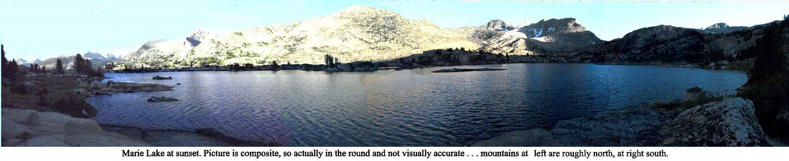 (sorry, you're just gonna have to click on this picture if you wanta really see it . . . )


