 DAY 16 - August 23, 2010: The mother of all foresters
 I knew when I crossed Muir Pass that there was no turning back. The road home lay through the passes Mather, Pinchot, Glen, and Forester . . . plus Whitney, as just a smidgeon of afterthought. That’s one way to get yourself to do something, hey? Put yourself in a position with just one way out.
I suppose it’s odd that after all these days and all these passes I’d think Forester Pass was tough. It’s no more than a foothill compared to Everest, or even Denali, that’s true. Be proud then, you lucky youngsters with great lungs and legs. Actually, looking back, I think that by the last few days I must have been not getting enough food, that was part of it. Keeping my energy up seemed an increasing problem. Figure out there you burn 5000 calories a day, and take in only about 1000 with the food you can carry. Lost a bunch of weight, which taken alone was good, but wow, I sure did tire fast! And if I was building muscle, where was the protein coming from? I remembered Bob saying he and Brad stopped every hour to eat. I didn’t have any snacks . . . too much to carry in the canister. If I were to do something like this again, I’d figure out a way of carrying more food.

 It was OK, though. Most of my blue funk from yesterday was gone, I’d slept maybe 15 hours since that afternoon, and the old body was creaking along purty good, all things considered. The guy yesterday had been right about one thing: the trail was easy to walk on. What he apparently didn’t notice was that up where it started zigzagging back and forth it got a whole lot steeper. I said, OK, just take your time, took it at a pace I could handle, and got up in good time, maybe around 10AM, just before another group came up from the other side. And the scenery was spectacular.
I got passed by a couple of parties, and by a whole string of young folks wearing what looked to be Explorer uniforms, some of whom were just tearing along the trail, some trailing far behind. Some were carrying tools, and I asked if they were doing trail maintenance. The answer was yes, they were with the California Conservation Corps. Aha, no wonder there were kids of mixed ethnicities there, some Hispanics and three or four blacks. It struck me suddenly that I hadn’t seen any black folks at all on the entire JMT up to this point. Now why the heck is that? I did see just a few up around Tuolumne, and again a few Latinos, but it seems the huge majority of hikers are us honkey-types. There are some Asians, but it seems to me that most of those are visiting from
 Japan or Korea, not a whole lot native-born from here. I hope that changes. Everyone who can should see this world, it’s a crown jewel of this part of the world. More, it’s a jewel in the crown of the world.
Passed the CCC folks at work, looked tough, prying up boulders, clearing rock falls. Thought about the descent at the top of LeConte Canyon, it would be good to send a crew like this up there for six or seven months! Ah, but yes, California is in a fiscal mess. But leave the politics alone for now, the trip isn’t about that.
 Could definitely feel the altitude, now that I was a thousand feet higher than ever before on the trip. If I hyperventilated, it really helped with the energy, but I found myself getting pretty dizzy, which never used to happen. I remember marching up 14,000-foot Mauna Kea with my Peace Corps group on the 4th of July, 1965, hardly breathing hard, and sure not dizzy. Wonder what the physiology of that one is?
 (don't forget to click on the pictures that look too small)


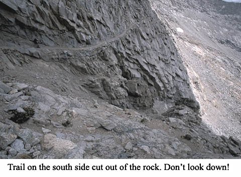 The dizziness wasn’t a problem on the way up, because the trail, while steep, was gentle. But going down! Rocky, steep, often with a precipitous drop. I was feeling pretty shaky, and at one point I started feeling much as I had going up to Evolution Valley now well over a week ago: my pupils dilated, things started looking too light, and I felt way too close to blacking out. I did not look down, but sat down on a flat granite rock, and gave myself a little lecture: no matter what, I had to get to the bottom of this descent. No falling over the edge allowed. Composed myself, started on down, always watching the feet, kept a steady pace, and was rewarded wit
 h a nice resting-spot at the bottom right by a gorgeous pond and ice-cold stream running down from it. That water had as sweet a taste as I’d ever known. Took a nice long break, almost napped.
One of the problems with doing something as long as the John Muir Trail is that you have to keep going: you’re on a schedule. Food will run out in a certain number of days. You may have to be somewhere on a certain date (last time I’d had to get back to work). So you can’t really step outside the box and have serious play time. I really felt like jumping in the water here, getting clean, doing a little swim, but then I’d have to take the time out to do that, dry off, get organized and go again. At this point I was getting pretty antsy to get out of the wilderness, and focusing more on that, no matter how much I was trying to live in the moment.
The scenery there in the upper basin of the Kern River was also exotic and starkly beautiful, in a different way than the peaks above. I was taking it in, but it is a measure of my impatience to move on that without knowing it, I almost completely stopped taking pictures, something I now regret. It was much like the Kings River Basin after Mather Pass, or the basin after Pinchot, with the source lakes for Woods Creek: high desert, dotted with lakes. The lakes along here were numerous, and mostly small, lined with big rocks. Jumbles of reddish boulders Some were just ponds, stagnant but clear, and shallow to the point wh
 ere by late afternoon the water would have warmed from the sun to a comfortably warm temperature. I hadn’t had a shower or bath since Vermillion, two weeks ago, and really felt like going in . . . but didn’t. Keep on slogging, gotta get as far as we can tonight, my mind said.
 Also just as with the other two basins, it was a long march before getting down into the trees again. My strides and breathing fell into a rhythm which had become standard for these long stretches of flat or uneventful downhill, I breathed in with one step and out with the next, and my throat and palate would form a note or series of note
 s with each breath, making
  for the repetition of a simple melody of no more than four bars duration. I’d hear these melodic phrases in my head and—without thinking about it—while not actually voicing them, breathe them in and out in a singsong w
 ay. I was thinking that maybe this is the way work songs started, as a natural response to repetitive motion and breathing.
The phrases were usually very simple-minded, hardly ever anything interesting, and most weren’t original in the
 least, I’d picked them up somewhere or other, but I thought I’d try to remember them and write them down when I got back. Here are a few. There were maybe 10 of them that just kept coming back, no point in writing them all down. Ac
 tually, this just shows how punchy I am, to even think about this. You’re laughing. A little respect, please.
When the trail, amazingly after only7.5 miles, crossed Tyndall Creek, it was already late afternoon, and I was wiped out. I’d planned on going up the next rise, another mile and about 400 feet to the Bighorn Plateau, but I’d been hiking for over 8 hours and decided that was enough. Tyndall had been my goal for the day anyway. Tomorrow was just a staging day, no passes, but had several steep climbs and drops. It was a question of either a ten-miler or an eleven-miler tomorrow, so I figured what the heck, bed down early and get an early start.
This staging is going to be the final one: I’ll camp at Guitar Lake, and day after tomorrow tackle Whitney. Finally. OK, to sleep, to gather strength. To sleep, perchance to dream . . . oh, no! “Call me Denti.” Let it be dreamless.
 Next Entry: The end in sight.


No comments:
Post a Comment