Total Pageviews

Monday, September 6, 2010

BACK WHERE WE BELONG

DAY 6 - August 13, 2010: Feels like home

Woke up refreshed, much better mood than yesterday, in spite of the mosquitoes, which were worse than they’d been below. Vermillion and the trek up from civilization already felt distant. The air was thin and crisp, the water was cold and clear and good-tasting. That stop down there, with the steak and the good breakfast, was a good thing, I guess, but it was distracting, not what I came up here for. Hey, what did I come up here for? Hmmm. Let’s think about that. Or, let’s not, right now. Right now, let’s just get going. Miles to go before I sleep, some beautiful miles ahead.

This has been one of the sweetest campsites I’ve had this summer, wide, soft ground, large granite stones to sit on. Bear Creek wide, calm, and gorgeous. Wish I could stay and hang out in this area for some days yet, but the schedule won’t let us wait. We’re already going to be a day behind my original plan, because Anniell’s plan calls for staying at Marie Lake tonight, where I’d had us starting two miles ahead of our current position and going all the way to Muir Trail Ranch. No matter, I hear Marie Lake is gorgeous, too. Anniell and I are good hiking buddies, I think it’s made it easier for each of us that the other has been along.

The guys yesterday were right, it was a walk of only another ten
or fifteen minutes before we hit the JMT again, and it felt strangely like home. The “10,000 ft – no wood campfires” sign was like an old friend. Back on track with the Whitney countdown. The uphill wasn’t crazy steep, and the trail wasn’t full of sharp rocks jutting out at crazy angles or steps of 2 feet up.

After a few minutes back on the JMT, it starts looking like a hikers’ freeway, a lot more folks than we’d seen before on the trail. I was suddenly passed by a cheerfully young couple carrying silver parasols, what a concept! I guess it was keeping them cool. I was tickled. It was like something out of a Cocteau movie, ever so slightly on the absurd side. But wait! Not two hours later I saw another silver umbrella, coming down from the other direction, and this guy . . . looked like he was wearing a skirt!
Then ran into a couple more couples of varying ages, and passed a bunch of young guys taking a long break.

Crossing another serious “rock-hopper” of a stream, waited for Anniell to come along, to see if she needed help. Just after she arrived, a group of guys on a fishing trip came marching energetically along, a couple of them with big, big bellies. I guess if you’re under 40 you can have those and still comfortably carry a pack up there . . . had to admire them, because I don’t think I could have! In their company was an older guy, in good shape, as it turned out a retired Army colonel. Anniell was hesitating, having trouble picking out the right spot to cross, but the colonel graciously offered to take her backpack across and let her follow without anything on her back, which they did. When he got over, though, he said aside to me “now that’s what you were supposed to do. They need to be spoiled sometimes.” To this I answered, “I was just encouraging her to be all that she can be.” Not sure if he got the reference. Anyhow everyone crossed safely. And the guys went on past, again marching along at an amazing pace.

Passed the parasol pair taking a break, and we waved to each other. At the next big stream following that I took my own break, filling water bottles and lying back on the grass for a few minutes, during which time the place filled up with people to the point where it was like a hikers’ convention. Anniell was talking to them of the umbrella persuasion, and suddenly the guy came over and introduced himself. “She says you’re a trumpet player. So am I,” he said. Turns out Mark and Julia are from St. Louis, where he freelances on the legit circuit and she plays with the St. Louis Symphony. We compared notes about practice methods, etc., and it was suddenly hard to feel we were way out in the middle of nowhere.


Wanting more solitude, I waited till everyone had moved on, including Anniell, before starting up again. The two of us arranged to meet where she was planning a lunch break, at Rose Meadow, where the climb up to Marie would start in earnest.

She was still munching and relaxing when I got there. One difference in our hiking styles is that I like to take a lot of short breaks, while she takes fewer and longer ones. So after a few minutes I moved on, and she said great, she’d catch up in a bit.


It actually wasn’t all that long before I pulled up to Marie Lake. This was a short day, only seven or eight miles, and it was great to get into this beautiful place early and have a chance to rest. And everybody had been right, this was a gem of a place. We were planning on camping at a stream crossing that showed on the map, but we never saw the stream, so we camped up at the southern end of the lake, just before Selden Pass, which we’d go over right around sunrise the next day, then on down to our resupply point at Muir Trail Ranch.

Somehow the trip so far just seems like a warm-up. I've been out nearly a week, you'd think it would feel like more than that, no? A warm-up to what? Well, after tomorrow, Anniell's friends will have caught up, that's the plan, and I'll be hiking alone, finding my own pace, probably having more inner conversations than socializing. Also I've already seen everything from Muir Trail Ranch up to Muir Pass, but everything after that—including the next 5 passes, plus Whitney—will be new, and I'll pretty much be committed to finishing the whole thing. Once over Muir Pass there's no easy exit except to just keep on truckin'.


Meanwhile, this brief rest at Marie Lake is one more experience among many that are, well, sublime.
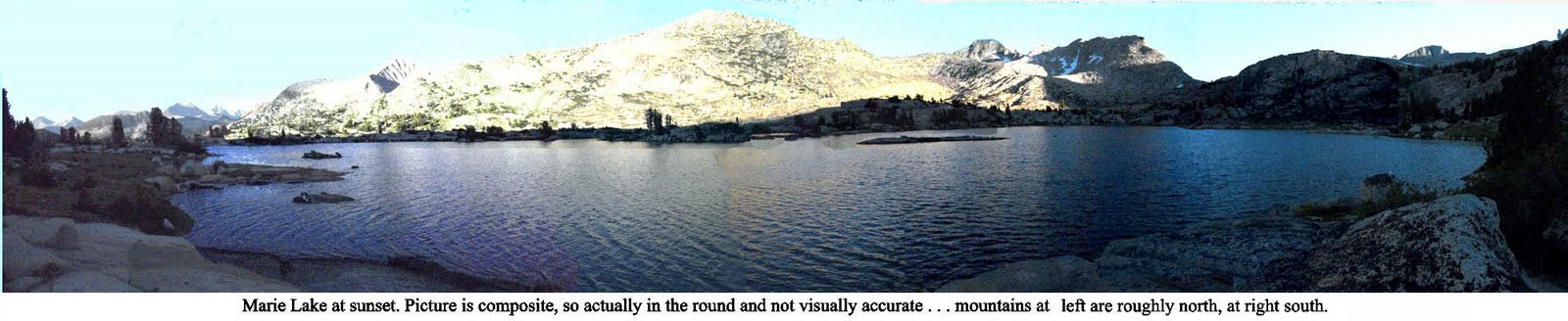
(sorry, you're just gonna have to click on this picture if you wanta really see it . . . )

Saturday, September 4, 2010

GETTING BACK TO ALTITUDE

DAY 5 - August 12, 2010: a whole day of uphill

The good thing about being at Vermillion this morning was that we didn’t have to move, move, move, get out in a hurry. The bad thing about being at Vermillion that morning was that we didn’t move, move, move, get out in a hurry.

This is a resupply point for Anniell. Her group had 4 resupplies: Red’s Meadow, Vermillion, Muir Trail Ranch, and Charlotte Lake. Couldn’t imagine why they needed that many, I only had one, at Muir Trail Ranch, 2 days down the line. But if we were to continue hiking together I’d have to wait for her to finish sorting through her stuff and sending things back to the friend who had opted out at Red’s. This didn’t bother me much at the time, since we didn’t have to scramble like everyone else to make the 9AM ferry back to the JMT cutoff trail at Mono Creek—we’d just march quickly up the Bear Creek Trail and cut off all that useless up and down on the JMT, which didn’t look very scenic anyway. Had a big breakfast, got organized and relaxed.

There were a couple of middle-aged guys there, brothers, who were also planning to take another route. The previous day the younger one had fallen flat on his face in a pond while hiking and torn his forehead and cheek all up. “Can’t take him anywhere,” said the older one. They were planning to compensate by having an easy day, going in through Florence Lake and playing around in lower country for a day or two before hiking up to beautiful Evolution Valley. So they’d hired a guy with a van to take them to the Florence Lake ferry. The Bear Creek trail was on the way, so we tagged along that far, and gave the driver another 20 for the favor.

What I hadn’t counted on, or thought out, was that he would be letting us out on a 4-wheel-drive-only road a couple of miles from the trailhead, and 600 feet lower than Vermillion, and only about a mile from Mono Hot Springs. This, of course, became clear as the van went down, down, down, and the high mountains started looking further and further away. He dropped us off maybe a quarter of a mile up the gravel road, and we cheerfully started walking up, and up, and up. It was hot, and none of the bubbling streams we were used to were anywhere to be seen. The mountains seemed very, very far. I realized I was missing being at and above 10,000 feet, where the air was so fresh and the breeze so cool.

In fact, I then realized, taking this trail was more of a disadvantage than otherwise. Here we were going to have to climb about 2800 feet to get to the JMT trail junction, as opposed to only about 1000-1200 on the other trail, plus we’d be hiking several extra miles, and still end up 2 miles short of my original goal for the day. And, far from the usual start time of 8AM or so, we didn’t get on the trail till 11. Was this lack of foresight? Perhaps.

For awhile, the steak (apologies, vegetarian friends, ut was a guilty enjoyment) and the big breakfast were carrying me through just fine. I didn’t have to stop and rest until we got to the trailhead at Bear Creek Diversion Dam, and we had enough water to get there—barely.

But from there, I figured, piece of cake. Just walk gently upstream till we reached the JMT. But NOT! for awhile it was like that, yes. And Bear Creek was the prettiest stream we’d seen on the trip so far, but . . . after a couple of miles the trail started going up at a steeper rate than I thought I’d ever seen, and besides, it wasn’t maintained well. There were sharp rocks, and twists and turns, muddy fords with no easy way to cross, and giant rock steps, which stressed the knees. The path then went away from the stream and what seemed to be practically straight up the sides of the cliffs and domes. I started moving slower and slower, and after we’d been going 4 or 5 hours, I was beginning to feel exhausted. Actually, almost defeated, as if my body finally was deciding it wasn’t really up to all this abuse. I honestly wanted to stop, but told myself to just suck it up, we had to make it, or the next day would be worse.

Fortunately, we’d met a bunch of guys hiking out who’d told us what to expect and where the best places to camp were. “Steep?” I asked, “Ohhh, yeeaah,” one replied. But the one who seemed to be the leader said “When the trail finally moves back towards the stream, the trail makes a narrow passage between two rock faces. When you come out of that, you’ll come into a lush green area, there are lots of beautiful spots to camp right by the creek, and you’ll be only about 15 minutes from the JMT.” Music to my ears, but the music was still somewhere far off in the distance.

Finally, after more than 8 hours of slogging, and about 10 hard, hard miles, about 7:30 PM, with not much light left in the day, we did in fact find the place he was talking about, and gratefully pitched camp at what was one of the prettiest spots we’d seen. There was a new moon that night, and it was nice to look at, for about five minutes before fatigue overcame me and I finally crashed out into what felt to be a dreamless sleep.

Next entry: the ridiculous and the sublime

Friday, September 3, 2010

WHERE DID THAT HAT COME FROM?

DAY 4 - August 11, 2010: a whole day of downhill

Well, so far, so good
. Here was the fourth day already, I was hiking pretty well, had no blisters or any other discomfort, had gone over the first pass of the seven before Whitney, and was camping in incredibly beautiful spots. So far it was pretty much like any other backpacking trip.


Tonight we’d actually touch base with civilization again. Where the trail descends to Edison Lake, a drop of nearly 3000 feet, before ascending again to 10,000+, there’s a twice-a-day ferry that takes weary backpackers to a little mountain resort, complete with a restaurant and a store. At Vermillion Resort they give JMT through-hikers a free beer and also let them stay in a tent-cabin bunkhouse. I hate to admit that after only four days I was looking forward to a little comfort. No matter that there were still more than two weeks to go . . . was I starting to feel a little smug? That first pass wasn’t easy, but it wasn’t hard, either. Donohue, three years ago, had been a lot harder, and I hadn’t had to make so much altitude on the same day. Was the JMT maybe going to be easier than I’d thought? Hmmm. Don’t jump to conclusions.
From the campsite we had to find the trail. as we walked out we saw a couple sitting on a rise a little above us, looking across at the movement of the shadows on the peaks, and they told us where it was. They (Rick and Dianne, as we later found out), had hiked over the pass really early in the morning to catch the sunrise.

We followed a creek down from Silver Pass Lake, and it swelled, first opening out into a wide meadow, then, as we came the steep side of a deep canyon, shooting off the top before sliding down a wide expanse of smooth granite and tumbling down in a cascades to join the north fork of Mono Creek.

When I reached the Mono Creek Trail turnoff, there was a tall signpost indicating that. I wish I’d taken a picture of that signpost. On top of it was a hat. Quite a good hat. Not sure what you’d call it, but it seemed a kind of cross between Panama and cowboy hat. A little medallion on the hat band which read “Adventure.” Ever curious, I tried it on. A perfect fit. Where had it come from?

There was no one around. The only reason I could imagine for that hat being there was that 1) someone had taken a break there and left it behind by mistake, then 2) someone else had come along, seen it, and put it in a prominent place so that the owner couldn’t miss it if he came back looking for it.

It was a great place for a break, good places to sit, and the stream was close, so I could refill my water bottles easily. Since we were aiming for the 4:30 ferry, this was a short day, and we had plenty of time.


I hadn’t brought a hat. Anniell and others I met on the trail had told me my face was getting quite red, and actually it was starting to feel a little uncomfortable. So, I thought. If the owner of the hat went uphill or downhill very far, he isn’t going to want to retrace his steps just to get his hat. And there’s a 50% chance he went downhill, same direction I’m going, so if I go that way and ask whomever I meet, I might run into the owner. And when I get to Vermillion I can ask at the store if anyone’s reported a missing hat. And if I don’t find anyone, well, the hat’s mine, I can use it to keep the sun off my face.

I waited until Anniell got there, and we took a kind of lunch break. Then Rick and Dianne pulled in, and we had a good hang with them. I told them what I’d been thinking about the hat, and they thought it made sense to follow up in that way. So I did. And so I became the proud and dapper owner of a very cool hat. Something new for me, I’ve never been one to wear hats.

We all got to the ferry landing quite early, so there was a long time to talk and get to know each other better. Joining in the conversation was a tall guy in his mid twenties named Chris, a bit of a hiking fanatic, who came up to spend huge chunks of time in the wilderness every summer. Some wild stories were told all around, and new friends were made.
Vermillion was quite a refreshing stop. We could, and did, for a price, get showers and do laundry. Got my free beer, slept in the tent bunkhouse, didn’t have to set up camp. And the café/restaurant, unlike just about any other of its kind I’ve seen, didn’t have hamburgers and hot dogs. What did they have? New York steak. Now I’m not that much of a carnivore, but I couldn’t resist this. And it was a HUGE cut. I could have eaten two. And out on the trail, you’re always burning way more calories than you take in, and are pretty much guaranteed to lose weight, so I wasn’t worrying about getting fat from that . . . I had probably already lost five pounds since July anyway. Had dinner and good conversation with Chris and Anniell. Shared lots of trail stories. Told Chris bout the 10-year-old boy I'd seen up there with his dad. He answered (more or less), "yeah, they're getting younger and younger. There was an 11-year-old and a 13-year-old who were just now the youngest to ever do the yo-yo."

"What's the 'yo-yo?'" I asked.

"That's where you walk the whole John Muir Trail, then you turn around and walk right back."

Hmm. Some kind of crazy, seemed to me. Actually, considering I still had15 more days in the trip, maybe I was kind of crazy.

Whatever, after dinner I felt like a million dollahs . . . .and the next day I'd have a great hat to keep the sun off my face.


We were looking for alternatives for the next day’s hike. Standard fare would be to take the ferry back, hike a mile and a half back up to the JMT, and start around 10AM hiking the 2500 feet back up to altitude, then drop down another 1000 before climbing up to the next pass, Selden. Anniell and I were going to have to leave late anyway, so taking the ferry was impractical. A lot of people advised us to instead take the Bear Creek Trail, which would just be a steady climb up to the JMT. Sounded easier. And on that note, I went back to the bunkhouse and conked out.

Next installment: How was that old Bear Creek Trail, anyhow?

Tuesday, August 31, 2010

AND OVER THE FIRST HUMP

DAY 3 - August 10, 2010: down, up, and over Silver pass

In the morning, it became much clearer
what a beautiful spot we'd picked to camp.
I've rarely in this long life seen as beautiful a sunrise as that one over Lake Virginia, sitting at 10,338 feet (3100m), the peaks and crags beyond reflected in crystalline perfection in the stillness of the water. It sits cradled up high in a shallow alpine basin, nearly as high as the surrounding ranges.

(note: you can click on these pictures and get a bigger, better view. The one above, for instance, really benefits from that)

In fact, the best story of this day is the natural beauty we moved through. My own personal story, at least for much of the day, was of discomfort. I woke up a little uncomfortable and shaky from the altitude, and besides, it was FREEZING, and besides, the mosquitoes were coming out in force, and we did have to drop 1500 feet, down even below Tully Hole, and then climb nearly 2000 up to get over the pass.


This, I’m starting to grasp, is much of what doing the JMT is about. Great beauty, a lot of discomfort. Having fun going down? Wait a minute, what goes down must come up, get ready! I’d see hikers doing the slow slog up the other way, but wouldn’t feel sorry for them, because we were both in the same boat. In not too long they’d be doing the down and I the up. Besides, the downs weren’t all that easy, either. A lot of them are rocky, and you have to watch your feet all the time to make sure you’re not stepping where you could twist an ankle, or slip and fall.
Downhills were hard for Anniell. Her right knee would get stiff, and she was constantly watching for swelling. Also, when it came to streams, she said “I’m not very good at rock-hopping.” So if I was ahead, I’d often wait if there was a stream that looked hard to cross, to make sure she’d get across OK. Most of them weren’t that hard.


The way up to Silver Pass, the first of seven 12- to 13-thousand foot passes we’d have to cross before Whitney, from the bottom of the trail at Fish creek was relentlessly steep. But I took my regular breaks, enjoyed the view, and had some good talks with other hikers coming up or going down. There was a thick, wide granite ledge above, and to the right a waterfall tumbled over it.Up above, I knew, was Squaw Lake, where we’d rest before going over the top. But where was the top? Looking up, I couldn’t see anything that would pass for a pass, just forbidding peaks and ridges curving around where the lake would be.

Once up at the lake the location of the pass wasn’t any more obvious. What the heck, the trail doesn’t lie. I got a head start on Anniell, who was still relaxing and having some snacks, and started up the steep twists and switchbacks that would get us there. I was seeing why the guidebook had called the first day’s scenery “monontonous.” This was anything but. The trail wound up and around a number of lakes, names inspired by the American Indian: Chief Lake, Warrior Lake, Papoose Lake, Lake of the Lone Indian. And
the higher we got the more scenic it was.

Nearing what had to be the top of the trail, I still couldn’t figure out where the pass was . . . couldn’t see a trail going over anywhere, and everything looked steep and forbidding. The place we seemed to be headed was covered with snow, still. Wait a minute . . . could it be? I saw figures moving above the snow. Hmm. Yes, that was where the trail was headed! When I got closer, I saw that the trail headed right into the snow field, but that there was a sort of rut off on the right side, that just went straight up, and it looked as if it had been made by people just scrabbling up, using hands and feet together. Hmm. What the heck, I figured it was a good day to die, so I just followed those tracks on up. Short and sweet, actually, not too hard, but it could have been a nasty drop if I’d slipped. Anyhow I got up, no problem, and it was sweet to be on the level top. One of the good hikers up there took my picture. One pass down, 6 to go. Not to mention Whitney.

From there it was just a mile or so down to our camp for the night at another stunner, Silver Pass Lake. We pitched camp at the far end of the lake near some trees, cooked dinner, and got another good long night’s rest. Ten hours, that's about what I've been doing!

Next entry: why didn’t I bring a hat?

Monday, August 30, 2010

THE SHOW MUST GO ON

DAY 2 - August 9, 2010:
Parting of the Ways


We woke before dawn. Jim was up first, with the coffee, as he had been for the week up in Tuolumne. I got up to answer an urgent call of nature, which required going some distance away for a few minutes. On my return, Jim had a cup of coffee for me, and something to tell me. He'd decided he wasn't going to be physically up to the trip, so he and Dustin weren't going to continue. The day before had pushed him beyond what he considered his safe zone, and he, probably rightly, figured that it would be bound to happen again, and he couldn't take the chance of losing his health.

He was right. It was my obsession to do this trail, not his. I felt guilty for having sold him on going, but he said no, he'd come in knowing he might not be able to do it and that it was better to recognize it now than later. It would have been great to have the company of an old friend, but it was not to be. Would it have been different if I'd not pushed to go on past Deer Creek last night? Or talked about pushing for Lake Virginia tonight? Maybe I hadn't been paying enough attention.

This was going to take time to sink in, but for the moment we had to make arrangements. Anniell and I decided we'd go on together for some time, hopefully until her two other hiking club friends caught up with us, at the Muir Trail Ranch resupply point. So we just took care of business, broke camp, saddled ourselves with the packs, and parted ways.

I was out of water because of the snafu with the map marking a non-existent stream. Not good, as it was a hot and dry day, and it looked to be awhile before water. Anniell's "Atlas," which had gotten us into that mess in the first place, showed no water along this stretch for some miles. Fortunately, it was wrong again. In about another mile we came to a bend where a stream of that sweet Sierra water, trickling down from an unknown snow melt somewhere above bubbled up, creating pools just deep enough to fill my water bottle.


After a few refreshing minutes, we again pushed onward and upward. Always a steady up, we were heading for the really high country now. I didn't feel as fresh as I had the day before, but it wasn't making much difference at this point. The trail, as noted in Jim's guide book, got rougher, turning from pumice to granite, much rockier, not so much fun to walk on. But the scenery started getting better.

We eventually reached the Duck Lake Trail junction, where a path splits off from the JMT to go over Duck Pass and back to Mammoth. Once we crossed the creek there, the trail started going seriously up, in rocky switchbacks, more like what I'd been used to in the Tuolumne high country. But suddenly things were a lot harder. We were over 10,000 feet now, and I was breathing hard. Started wondering how it would be doing this day in, day out. I started falling into a pattern of taking lots of rests. The old heart would be pumping, I'd be panting, and when it got uncomfortable, then would be time to find a nice flat granite rock where I could sit with the pack weight supported behind me. In the old days I didn't often do this, but I figured I'd give myself a break, hey, I'm kind of old now, I guess, anyhow, that's what the numbers say. Plus it gave me plenty of great opportunities to sit, contemplate, and enjoy the view. And I was generally getting to the top of these uphills about the same speed as Anniell anyway, so it worked out.

There were two of those steep uphills today: up from the junction before the descent to Purple Lake, and up from Purple Lake to Lake Virginia. Somehow I didn't have yesterday's energy, and they were tough slogs. But, as they always say, it's beautiful up there. And, dammit, that's true in spades. These lakes were the prettiest sights we'd seen yet, but I knew they were only a little taste of what was to come.

At the outlet of Purple Lake was a group of maybe 20 Sierra Club backpackers, on a three day loop trip, going out the next day at McGee Pass. They were finishing up a long break, and started up the 500-foot climb on the other side of the creek to Lake Virginia. Quite a variety of hikers. The ones out front really frisky, practically bounding up. Bringing up the rear were some really slow folks, aged about 45 to 60, I'd say, some of whom looked as if they'd rather be anywhere else. So far I didn't feel that way. I was thinking of Nietsche's "was mich nicht umbringt, macht mich stärker" (If it doesn't kill me, it makes me stronger), and so put heart into it, no matter how slowly I was moving. But wondering why I didn't have yesterday's energy. Anyhow I got a head start on Anniell, who was still eating lunch. I think that if today had a lesson for me—beyond the lessons I was still trying to work out about Jim and Dustin leaving—it was about pacing myself. I started developing a more comfortable system for hiking uphill.

There was a trail maintenance crew about halfway up. "Hey, almost there!" they shouted, "hard part's over!"

And not too late in the afternoon, though later than I'd have liked, we got to the promised land, Lake Virginia. The original trail plan had called for camping at Purple Lake. We got 2 miles further on. Not too shabby. And this lake was gorgeous. The Sierra is so full of variety, the same themes played out in innumerable ways.

The mosquitoes were pretty bad, but no where nearly as bad as on my Tuolumne warm-up loops, where there were times I'd breathe in and get a throatful of bugs. Those pesky little bastardesses have a very short season, and I could tell it was closing down. I'd brought along a mosquito head and body net, but so far hadn't had to use it on this trip. Anniell, on the other hand, was using hers.

Dog-tired, after a quick dinner, I hit the sack and was out by the time it was dark. Looking forward to the freshness of a new day, which would at least have some downhill at the beginning. On to Tully Hole, and Selden Pass.

Next entry: Where the hell is the pass, anyhow?

Friday, August 27, 2010

WATERSHED

I remember, many years ago when living in Marin County, California, a bunch of us hiking a fire trail to the lake/reservoir over the hill from the house. On the way back uphill, my little sister Nina, then nearly 20 years old, commented that she'd never enjoyed hiking, because however beautiful the surroundings, it felt like hard work. I said, "look at it this way . . . your muscles are moving together in harmony, you're in a way massaging yourself. If you concentrate on bringing that image to the front of your mind, pretty soon you'll feel you're gliding uphill while getting a massage."

Well, she snorted and didn't buy it. Of course neither did I, really, but back in my primo backpacking days the workout was kind of enjoyable, and every single time on return from a 3- or 4-day trip I'd feel revitalized.

My family moved to California when I was 10. By the time 11 rolled around, I'd already fallen in love with the California mountains. I remember the first brisk whiff of that wholesome, tangy Douglas Fir scent when visiting the Mt. Wilson Observatory in Angeles National Forest, repeated at Mt. Baldy, Big Bear Lake, and finally, Yosemite, the crown jewel of the National Park System. At 14 I climbed to the top of Yosemite Falls with my dad. At 18 I worked with the Forest Service in Plumas County for a summer. On graduation from Berkeley in '65, the week before flying off to join Peace Corps Thailand a bunch of us classmates backpacked up to camp overnight at Little Yosemite Valley before hiking up to climb Half Dome the next day. And I kept on doing things like that in every decade of my life, and did my best to get my kids on the same track, taking them up there from their earliest years.

Also around the 11-year mark, my imagination was captivated by a slide show presented by a family of four, with two young kids, who had taken a month and hiked something called the "John Muir Trail," (now known by hikers as "the JMT"), which began in Yosemite Valley and meandered 211 miles through roadless wilderness to the top of Mt. Whitney, at 14,496ft (4,418m) the highest mountain in the U.S. outside Alaska.

The images they showed were of unbelievably beautiful and varied tapestries of mountain, forest, stream, and meadow. From that day I had it in my mind to do the trip someday. After not too many years I'd done all the pieces of it within Yosemite National Park. But I'd never tackled the whole thing, and kept thinking how very cool it would be to really go up there and see all that fine country. The Sierra Nevada, or "snowy mountain range," which John Muir said would be more aptly named "the Range of Light":

"After ten years spent in the heart of it, rejoicing and wondering, bathing in its glorious floods of light, seeing the sunbursts of morning among the icy peaks, the noonday radiance on the trees and rocks and snow, the flush of alpenglow, and a thousand dashing waterfalls with their marvelous abundance of irised spray, it still seems to me above all others the Range of Light."

Then in 2007, at age 63 and a year before retirement, I thought I'd give it a go. Unfortunately a lot of things went wrong, and I ended up just doing a couple more pieces of the trail. Many of my friends know this story, but if you're interested, you can read here a copy of the letter I sent around at that time. I thought, hey, I'm getting pretty old, maybe I won't try it again. But then, who knows? Even that chopped-up attempt did a lot of good things.

A couple of years went by. I retired, moved to Thailand, and got into all sorts of great stuff, but, having chosen to live in the most decadent, urban environment possible there—Bangkok—got into all sorts of bad habits of urban life, including but not limited to eating and drinking too much, and not exercising, all that. Anyhow finally this year I—with encouragement and assistance from my old college and (PEACE CORPS THAILAND!) buddy Jim Weil—somehow put it all together to get back to the California high country and revisit that long-standing magnificent obsession. On August 8th Jim, his son Dustin, and I set up camp at Red's Meadow, where the wheels had begun to come off during my earlier JMT trek, and the next morning packed up, threw on the packs for the first time, and lugged them up the hill to big breakfasts at the Red's Meadow Café in preparation for another attempt: 18 days through the wilderness, again aiming for the top of Whitney.


Just about to get up and start, we were chatting with a couple of women who also looked ready to head out. They were members of an Appalachian hiking group and had come from Tuolumne Meadows to Red's over three or four days. But one had developed a knee injury and was unable to go on. "I hope you keep an eye on my girl up there," she said to us, indicating her friend. After talking a little more, we offered to have her hike with us if she'd like. So when we went outside and finally got moving, there were four of us, me, Jim, Dustin, and Anniell, this wiry-tough and wonderfully wacky woman from Texas via Washington, D.C.

This time, I actually completed the dream
, reached the top of Whitney, and somehow made my way tortuously down and out to civilization the next day. For me it was a huge effort, even harder than I'd thought it would be. There were many times out there when I wondered just why the hell I was doing this. There were a couple of times when, could I have actually wished myself out, I might have done it. But through it all the awareness was there that the trip was doing a lot of great things for me, and that when it was over, I'd see it as a watershed, a major statement, a deepening of my natural education, with lots of good results flowing from it out to my future, hopefully all the way to the end of my life. This, even though back at the outset I as yet had no idea how much there was to learn about hat design, new possibilities for duct tape, what to do with dirty socks, all the really good stuff, imagine!

I didn't ever feel much like writing after getting off the trail at the end of one of those nineteen long, tiring days, but did take as many notes as I could force myself to. And so, presently, I shall regale you with such minimally assisted memories as I can of the happenings and impressions of each day. Hope you can get a little something from this dark and deep, painful and pleasant, awful and wonderful experience, also. Note: in spite of starting out with a cluster of friends, I ended up doing the bulk of the hike quite alone. This made the experience quite a bit more intense, and probably more personally meaningful, but just how won't become clear till the later entries in this blog.


DAY 1 - August 8, 2010: Through the burned forest, and maybe too far past Deer Creek

After finding the way up to the JMT (just up past the stables, off to the left there) our little foursome set off up not the yellow brick road—yes, our party did sometimes feel a bit Ozzish—but a trail of pounded pumice that made for good walking but led up, up, up, through a burnt-out forest (fire of '92, patiently regenerating itself at a majestically slow pace). At first I was right behind Anniell, out in front of the others. She was setting a pace which felt perfect for me. I was feeling surprisingly good. This has been a very wet and snowy year, so vegetation was lush. The ferns along the early part of the trail had grown in so far so fast that it was sometimes hard to see that a lot of people had been going through. Anniell was thinking for a while that we'd gone off track somehow, but no.

We were aiming for one of our shortest hikes, under seven miles, starting at 7430 feet (2265m) and gradually getting up to over 9,000. About a 1600-foot (490m) rise, in a kind of warm-up for the 9-mile daily averages we'd planned. I'd done some prep back in July, a couple of three-day backpacking loops up to 11,000 feet and a lot of long day hikes, but Jim and Dustin were new to this, having only spent a few days at altitude and a done few short day outings. We'd stop at Deer Creek, which showed on the map and guides as a good place to pitch camp, scenic and with plenty of water. The next day we'd be heading for Purple Lake. The guide book was a bit discouraging, saying that the bulk of these two days would bring us through the "most monotonous" section of the Muir Trail. But I thought it was beautiful anyway, with the deep forest (once past the burned-out part) offering occasional glimpses of sweet vistas back towards the Minaret peaks of the Ritter Range, in the direction of Yosemite.

Anniell kept looking back ("It's the mother in me," she said) to check on Dustin and Jim, and eventually dropped back closer to them while I hiked out in front. I hoped I wasn't neglecting them. Those guys seemed to be doing OK, and we did check in every now and then.

Eventually we reached a long meadow with a beautiful wide creek. The distance seemed short, but we thought this must be Deer Meadow. Since it was pretty early in the afternoon, we stopped to reassess
—should we go on and make more miles?

Anyhow, it was a great place for a break. We eventually decided Deer Creek was further along, and so humped for quite awhile, eventually getting to the real one. Norm and Helen, a couple of 50-something hikers who were doing a 5-day loop, had already set up at one of the existing campsites.

My left foot was feeling a little pinched. Oh well, take a look when we set up camp. There were still hiking hours left in the day—again, pitch camp, or try to get further along? Anniell had something called the John Muir Trail Atlas, which I'd never seen, and it showed a likely spot for camping, with water, just about a mile up the trail. We all agreed that it was probably better to go on, making for a shorter trip tomorrow. So we hiked on. And on. And on. Stilll no creeks, no sign of water. I was feeling just too frisky, pacing way on out ahead, always sure water was just around the next bend or next rise. But I must have hiked two miles before realizing that the map must have been wrong. The Sierra mostly had streams all over the place, but this must be one section where that wasn't the case. So I sat down and waited for the others to catch up.

As it was, I had to wait quite a few minutes, and the afternoon was wearing on and on, light was slowly lessening. When they got here we'd have to camp, and just make do with the water we were carrying. It would be enough for dinner and drinking that evening, but the next day we'd be low. First lesson of the trip: always make sure you're going to have enough water to get where you're going, and that there's enough to restock when you get there.

Jim and Dustin finally pulled in, and Jim looked about done in. Not good for the first day. Not long after, Anniell came along a little late because she'd stopped to talk with the Deer Creek campers for quite a while. It was a good spot to pitch tents, lots of open spaces among the trees.

We set up the three tents, cooked pretty much separate dinners, and got to bed early. Anniell and I were hoping that because we'd actually done 8 miles instead of the planned 6, we might be able to hike on a bit further than planned the next day, make it up to Lake Virginia instead of only to Purple Lake. Jim seemed hesitant. I wish I'd paid more attention to that. As we lay down and got ready to sleep (always easy for me up there, since at the end of a day I'm always tired) Jim was reading aloud to us a description from his guidebook of the next day's hike. Wildflowers, eventually meadows. A change from pumice to granite on the trail. It was nice listening, then drifting off. Tomorrow we'd get to Lake Virginia, I was sure. Seemed we'd had a good first day after all, that's what I was thinking.

Next entry: Was I thinking
right?

Saturday, August 7, 2010

Life's Other Dimensions

Though having meant to follow up months ago with more rants about the current politics of my adopted country, and though there are plenty more observations to make, in those months I’ve slipped off into other worlds. I’m sure those issues will rise again to the top of our concerns, because the surreal revolutionary farce that consumed so much of our attention was just one act in a drama that’s far from over. Maybe I’ll go back later to revisit the fascinating aftermath, the no-confidence debate in Parliament, the posing and posturing on all sides, the attempts at healing the divisions that are being carved and gouged and picked at by those who hope to profit from them, the questions about who did what to whom and who is covering for whom, all those issues that we’d like to just go away, so we can get on with our lives. Maybe later. The last round was kinda exhausting.

So, other worlds. I’ve been trying to get on with my own life by following an old dream, which has sent me back for a few months to the country of my birth, so at this point I can send you greetings from the decadent old U.S. of A., where, strangely enough, I’ve come to find a little spiritual peace while paying some attention to this of late much-neglected physical body.


And so far, so good. In a couple of days I’m making another try at the John Muir Trail, starting at Red’s Meadow, where in 2007 the wheels started to come off my earlier attempt. This will involve about 18 days of hiking, about 160 miles (about 240 km) in altitudes generally between 9000 and 13000 feet (2700-4000m), over 7 major passes, capping the trip at the top of Mt. Whitney, the highest point in the U.S. outside of Alaska.

I make no promises about finishing—that was one big mistake last time—but right now it feels good. After more or less a month of preparation, I’m in a hotel room in Mammoth Lakes, with Jim Weil—classmate and buddy at Cal Berkeley and fellow Peace Corps Thailand alum, too!—and his son Dustin, and tomorrow we’re moving to our jump-off spot, we’ll actually start moving on Sunday the 8th. Will be taking notes and will try to give you a blow-by-blow after it’s over, say early September. By then I’ll have spent most of the summer up here in the high country.

The pictures here I took on yesterday’s day hike, a loop of about 13 miles, up from Tuolumne Meadows to Young Lakes and back.


Am just getting used to my new camera: the old one was lost at Ireland Lake a few weeks ago when the trail decided to disappear on me and I got a little flustered and put the camera down someplace by mistake. Missing some spectacular pictures, too, dagnabit. But that experience, as were others that of themselves don’t sound so great—hiking in the rain, pitching camp in a thunderstorm, coping with swarming clouds of mosquitoes, getting sunburned,


and on and on—was just part of this great meditation that hiking the High Sierra is. Learning so much about living in the moment, and feeling stronger and better with it all the time.

So, all for now. It’s late, gotta get an early start. But stay tuned. Just be patient, it will be awhile . . . but for the three of us, whee, here we go!


(click here for next installment)