DAY 3 - August 10, 2010: down, up, and over Silver pass
In the morning, it became much clearer what a beautiful spot we'd picked to camp. I've rarely in this long life seen as beautiful a sunrise as that one over Lake Virginia, sitting at 10,338 feet (3100m), the peaks and crags beyond reflected in crystalline perfection in the stillness of the water. It sits cradled up high in a shallow alpine basin, nearly as high as the surrounding ranges.
(note: you can click on these pictures and get a bigger, better view. The one above, for instance, really benefits from that)
In fact, the best story of this day is the natural beauty we moved through. My own personal story, at least for much of the day, was of discomfort. I woke up a little uncomfortable and shaky from the altitude, and besides, it was FREEZING, and besides, the mosquitoes were coming out in force, and we did have to drop 1500 feet, down even below Tully Hole, and then climb nearly 2000 up to get over the pass.
This, I’m starting to grasp, is much of what doing the JMT is about. Great beauty, a lot of discomfort. Having fun going down? Wait a minute, what goes down must come up, get ready! I’d see hikers doing the slow slog up the other way, but wouldn’t feel sorry for them, because we were both in the same boat. In not too long they’d be doing the down and I the up. Besides, the downs weren’t all that easy, either. A lot of them are rocky, and you have to watch your feet all the time to make sure you’re not stepping where you could twist an ankle, or slip and fall.
Downhills were hard for Anniell. Her right knee would get stiff, and she was constantly watching for swelling. Also, when it came to streams, she said “I’m not very good at rock-hopping.” So if I was ahead, I’d often wait if there was a stream that looked hard to cross, to make sure she’d get across OK. Most of them weren’t that hard.
The way up to Silver Pass, the first of seven 12- to 13-thousand foot passes we’d have to cross before Whitney, from the bottom of the trail at Fish creek was relentlessly steep. But I took my regular breaks, enjoyed the view, and had some good talks with other hikers coming up or going down. There was a thick, wide granite ledge above, and to the right a waterfall tumbled over it.Up above, I knew, was Squaw Lake, where we’d rest before going over the top. But where was the top? Looking up, I couldn’t see anything that would pass for a pass, just forbidding peaks and ridges curving around where the lake would be.
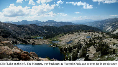
Once up at the lake the location of the pass wasn’t any more obvious. What the heck, the trail doesn’t lie. I got a head start on Anniell, who was still relaxing and having some snacks, and started up the steep twists and switchbacks that would get us there. I was seeing why the guidebook had called the first day’s scenery “monontonous.” This was anything but. The trail wound up and around a number of lakes, names inspired by the American Indian: Chief Lake, Warrior Lake, Papoose Lake, Lake of the Lone Indian. And
the higher we got the more scenic it was.
Nearing what had to be the top of the trail, I still couldn’t figure out where the pass was . . . couldn’t see a trail going over anywhere, and everything looked steep and forbidding. The place we seemed to be headed was covered with snow, still. Wait a minute . . . could it be? I saw figures moving above the snow. Hmm. Yes, that was where the trail was headed! When I got closer, I saw that the trail headed right into the snow field, but that there was a sort of rut off on the right side, that just went straight up, and it looked as if it had been made by people just scrabbling up, using hands and feet together. Hmm. What the heck, I figured it was a good day to die, so I just followed those tracks on up. Short and sweet, actually, not too hard, but it could have been a nasty drop if I’d slipped. Anyhow I got up, no problem, and it was sweet to be on the level top. One of the good hikers up there took my picture. One pass down, 6 to go. Not to mention Whitney.
From there it was just a mile or so down to our camp for the night at another stunner, Silver Pass Lake. We pitched camp at the far end of the lake near some trees, cooked dinner, and got another good long night’s rest. Ten hours, that's about what I've been doing!
Next entry: why didn’t I bring a hat?
Tuesday, August 31, 2010
Monday, August 30, 2010
THE SHOW MUST GO ON
DAY 2 - August 9, 2010:
Parting of the Ways
We woke before dawn. Jim was up first, with the coffee, as he had been for the week up in Tuolumne. I got up to answer an urgent call of nature, which required going some distance away for a few minutes. On my return, Jim had a cup of coffee for me, and something to tell me. He'd decided he wasn't going to be physically up to the trip, so he and Dustin weren't going to continue. The day before had pushed him beyond what he considered his safe zone, and he, probably rightly, figured that it would be bound to happen again, and he couldn't take the chance of losing his health.
He was right. It was my obsession to do this trail, not his. I felt guilty for having sold him on going, but he said no, he'd come in knowing he might not be able to do it and that it was better to recognize it now than later. It would have been great to have the company of an old friend, but it was not to be. Would it have been different if I'd not pushed to go on past Deer Creek last night? Or talked about pushing for Lake Virginia tonight? Maybe I hadn't been paying enough attention.
This was going to take time to sink in, but for the moment we had to make arrangements. Anniell and I decided we'd go on together for some time, hopefully until her two other hiking club friends caught up with us, at the Muir Trail Ranch resupply point. So we just took care of business, broke camp, saddled ourselves with the packs, and parted ways.
I was out of water because of the snafu with the map marking a non-existent stream. Not good, as it was a hot and dry day, and it looked to be awhile before water. Anniell's "Atlas," which had gotten us into that mess in the first place, showed no water along this stretch for some miles. Fortunately, it was wrong again. In about another mile we came to a bend where a stream of that sweet Sierra water, trickling down from an unknown snow melt somewhere above bubbled up, creating pools just deep enough to fill my water bottle.
After a few refreshing minutes, we again pushed onward and upward. Always a steady up, we were heading for the really high country now. I didn't feel as fresh as I had the day before, but it wasn't making much difference at this point. The trail, as noted in Jim's guide book, got rougher, turning from pumice to granite, much rockier, not so much fun to walk on. But the scenery started getting better.
We eventually reached the Duck Lake Trail junction, where a path splits off from the JMT to go over Duck Pass and back to Mammoth. Once we crossed the creek there, the trail started going seriously up, in rocky switchbacks, more like what I'd been used to in the Tuolumne high country. But suddenly things were a lot harder. We were over 10,000 feet now, and I was breathing hard. Started wondering how it would be doing this day in, day out. I started falling into a pattern of taking lots of rests. The old heart would be pumping, I'd be panting, and when it got uncomfortable, then would be time to find a nice flat granite rock where I could sit with the pack weight supported behind me. In the old days I didn't often do this, but I figured I'd give myself a break, hey, I'm kind of old now, I guess, anyhow, that's what the numbers say. Plus it gave me plenty of great opportunities to sit, contemplate, and enjoy the view. And I was generally getting to the top of these uphills about the same speed as Anniell anyway, so it worked out.
There were two of those steep uphills today: up from the junction before the descent to Purple Lake, and up from Purple Lake to Lake Virginia. Somehow I didn't have yesterday's energy, and they were tough slogs. But, as they always say, it's beautiful up there. And, dammit, that's true in spades. These lakes were the prettiest sights we'd seen yet, but I knew they were only a little taste of what was to come.
At the outlet of Purple Lake was a group of maybe 20 Sierra Club backpackers, on a three day loop trip, going out the next day at McGee Pass. They were finishing up a long break, and started up the 500-foot climb on the other side of the creek to Lake Virginia. Quite a variety of hikers. The ones out front really frisky, practically bounding up. Bringing up the rear were some really slow folks, aged about 45 to 60, I'd say, some of whom looked as if they'd rather be anywhere else. So far I didn't feel that way. I was thinking of Nietsche's "was mich nicht umbringt, macht mich stärker" (If it doesn't kill me, it makes me stronger), and so put heart into it, no matter how slowly I was moving. But wondering why I didn't have yesterday's energy. Anyhow I got a head start on Anniell, who was still eating lunch. I think that if today had a lesson for me—beyond the lessons I was still trying to work out about Jim and Dustin leaving—it was about pacing myself. I started developing a more comfortable system for hiking uphill.
There was a trail maintenance crew about halfway up. "Hey, almost there!" they shouted, "hard part's over!"
And not too late in the afternoon, though later than I'd have liked, we got to the promised land, Lake Virginia. The original trail plan had called for camping at Purple Lake. We got 2 miles further on. Not too shabby. And this lake was gorgeous. The Sierra is so full of variety, the same themes played out in innumerable ways.
The mosquitoes were pretty bad, but no where nearly as bad as on my Tuolumne warm-up loops, where there were times I'd breathe in and get a throatful of bugs. Those pesky little bastardesses have a very short season, and I could tell it was closing down. I'd brought along a mosquito head and body net, but so far hadn't had to use it on this trip. Anniell, on the other hand, was using hers.
Dog-tired, after a quick dinner, I hit the sack and was out by the time it was dark. Looking forward to the freshness of a new day, which would at least have some downhill at the beginning. On to Tully Hole, and Selden Pass.
Next entry: Where the hell is the pass, anyhow?
Labels:
Duck Lake,
hiking,
JMT,
john muir trail,
minarets,
range of light,
sierra nevada,
Virginia Lake
Friday, August 27, 2010
WATERSHED
I remember, many years ago when living in Marin County, California, a bunch of us hiking a fire trail to the lake/reservoir over the hill from the house. On the way back uphill, my little sister Nina, then nearly 20 years old, commented that she'd never enjoyed hiking, because however beautiful the surroundings, it felt like hard work. I said, "look at it this way . . . your muscles are moving together in harmony, you're in a way massaging yourself. If you concentrate on bringing that image to the front of your mind, pretty soon you'll feel you're gliding uphill while getting a massage."
Well, she snorted and didn't buy it. Of course neither did I, really, but back in my primo backpacking days the workout was kind of enjoyable, and every single time on return from a 3- or 4-day trip I'd feel revitalized.
My family moved to California when I was 10. By the time 11 rolled around, I'd already fallen in love with the California mountains. I remember the first brisk whiff of that wholesome, tangy Douglas Fir scent when visiting the Mt. Wilson Observatory in Angeles National Forest, repeated at Mt. Baldy, Big Bear Lake, and finally, Yosemite, the crown jewel of the National Park System. At 14 I climbed to the top of Yosemite Falls with my dad. At 18 I worked with the Forest Service in Plumas County for a summer. On graduation from Berkeley in '65, the week before flying off to join Peace Corps Thailand a bunch of us classmates backpacked up to camp overnight at Little Yosemite Valley before hiking up to climb Half Dome the next day. And I kept on doing things like that in every decade of my life, and did my best to get my kids on the same track, taking them up there from their earliest years.
Also around the 11-year mark, my imagination was captivated by a slide show presented by a family of four, with two young kids, who had taken a month and hiked something called the "John Muir Trail," (now known by hikers as "the JMT"), which began in Yosemite Valley and meandered 211 miles through roadless wilderness to the top of Mt. Whitney, at 14,496ft (4,418m) the highest mountain in the U.S. outside Alaska.
The images they showed were of unbelievably beautiful and varied tapestries of mountain, forest, stream, and meadow. From that day I had it in my mind to do the trip someday. After not too many years I'd done all the pieces of it within Yosemite National Park. But I'd never tackled the whole thing, and kept thinking how very cool it would be to really go up there and see all that fine country. The Sierra Nevada, or "snowy mountain range," which John Muir said would be more aptly named "the Range of Light":
"After ten years spent in the heart of it, rejoicing and wondering, bathing in its glorious floods of light, seeing the sunbursts of morning among the icy peaks, the noonday radiance on the trees and rocks and snow, the flush of alpenglow, and a thousand dashing waterfalls with their marvelous abundance of irised spray, it still seems to me above all others the Range of Light."
Then in 2007, at age 63 and a year before retirement, I thought I'd give it a go. Unfortunately a lot of things went wrong, and I ended up just doing a couple more pieces of the trail. Many of my friends know this story, but if you're interested, you can read here a copy of the letter I sent around at that time. I thought, hey, I'm getting pretty old, maybe I won't try it again. But then, who knows? Even that chopped-up attempt did a lot of good things.
A couple of years went by. I retired, moved to Thailand, and got into all sorts of great stuff, but, having chosen to live in the most decadent, urban environment possible there—Bangkok—got into all sorts of bad habits of urban life, including but not limited to eating and drinking too much, and not exercising, all that. Anyhow finally this year I—with encouragement and assistance from my old college and (PEACE CORPS THAILAND!) buddy Jim Weil—somehow put it all together to get back to the California high country and revisit that long-standing magnificent obsession. On August 8th Jim, his son Dustin, and I set up camp at Red's Meadow, where the wheels had begun to come off during my earlier JMT trek, and the next morning packed up, threw on the packs for the first time, and lugged them up the hill to big breakfasts at the Red's Meadow Café in preparation for another attempt: 18 days through the wilderness, again aiming for the top of Whitney.
Just about to get up and start, we were chatting with a couple of women who also looked ready to head out. They were members of an Appalachian hiking group and had come from Tuolumne Meadows to Red's over three or four days. But one had developed a knee injury and was unable to go on. "I hope you keep an eye on my girl up there," she said to us, indicating her friend. After talking a little more, we offered to have her hike with us if she'd like. So when we went outside and finally got moving, there were four of us, me, Jim, Dustin, and Anniell, this wiry-tough and wonderfully wacky woman from Texas via Washington, D.C.
This time, I actually completed the dream, reached the top of Whitney, and somehow made my way tortuously down and out to civilization the next day. For me it was a huge effort, even harder than I'd thought it would be. There were many times out there when I wondered just why the hell I was doing this. There were a couple of times when, could I have actually wished myself out, I might have done it. But through it all the awareness was there that the trip was doing a lot of great things for me, and that when it was over, I'd see it as a watershed, a major statement, a deepening of my natural education, with lots of good results flowing from it out to my future, hopefully all the way to the end of my life. This, even though back at the outset I as yet had no idea how much there was to learn about hat design, new possibilities for duct tape, what to do with dirty socks, all the really good stuff, imagine!
I didn't ever feel much like writing after getting off the trail at the end of one of those nineteen long, tiring days, but did take as many notes as I could force myself to. And so, presently, I shall regale you with such minimally assisted memories as I can of the happenings and impressions of each day. Hope you can get a little something from this dark and deep, painful and pleasant, awful and wonderful experience, also. Note: in spite of starting out with a cluster of friends, I ended up doing the bulk of the hike quite alone. This made the experience quite a bit more intense, and probably more personally meaningful, but just how won't become clear till the later entries in this blog.
DAY 1 - August 8, 2010: Through the burned forest, and maybe too far past Deer Creek
After finding the way up to the JMT (just up past the stables, off to the left there) our little foursome set off up not the yellow brick road—yes, our party did sometimes feel a bit Ozzish—but a trail of pounded pumice that made for good walking but led up, up, up, through a burnt-out forest (fire of '92, patiently regenerating itself at a majestically slow pace). At first I was right behind Anniell, out in front of the others. She was setting a pace which felt perfect for me. I was feeling surprisingly good. This has been a very wet and snowy year, so vegetation was lush. The ferns along the early part of the trail had grown in so far so fast that it was sometimes hard to see that a lot of people had been going through. Anniell was thinking for a while that we'd gone off track somehow, but no.
We were aiming for one of our shortest hikes, under seven miles, starting at 7430 feet (2265m) and gradually getting up to over 9,000. About a 1600-foot (490m) rise, in a kind of warm-up for the 9-mile daily averages we'd planned. I'd done some prep back in July, a couple of three-day backpacking loops up to 11,000 feet and a lot of long day hikes, but Jim and Dustin were new to this, having only spent a few days at altitude and a done few short day outings. We'd stop at Deer Creek, which showed on the map and guides as a good place to pitch camp, scenic and with plenty of water. The next day we'd be heading for Purple Lake. The guide book was a bit discouraging, saying that the bulk of these two days would bring us through the "most monotonous" section of the Muir Trail. But I thought it was beautiful anyway, with the deep forest (once past the burned-out part) offering occasional glimpses of sweet vistas back towards the Minaret peaks of the Ritter Range, in the direction of Yosemite.
Anniell kept looking back ("It's the mother in me," she said) to check on Dustin and Jim, and eventually dropped back closer to them while I hiked out in front. I hoped I wasn't neglecting them. Those guys seemed to be doing OK, and we did check in every now and then.
Eventually we reached a long meadow with a beautiful wide creek. The distance seemed short, but we thought this must be Deer Meadow. Since it was pretty early in the afternoon, we stopped to reassess—should we go on and make more miles?
Anyhow, it was a great place for a break. We eventually decided Deer Creek was further along, and so humped for quite awhile, eventually getting to the real one. Norm and Helen, a couple of 50-something hikers who were doing a 5-day loop, had already set up at one of the existing campsites.
My left foot was feeling a little pinched. Oh well, take a look when we set up camp. There were still hiking hours left in the day—again, pitch camp, or try to get further along? Anniell had something called the John Muir Trail Atlas, which I'd never seen, and it showed a likely spot for camping, with water, just about a mile up the trail. We all agreed that it was probably better to go on, making for a shorter trip tomorrow. So we hiked on. And on. And on. Stilll no creeks, no sign of water. I was feeling just too frisky, pacing way on out ahead, always sure water was just around the next bend or next rise. But I must have hiked two miles before realizing that the map must have been wrong. The Sierra mostly had streams all over the place, but this must be one section where that wasn't the case. So I sat down and waited for the others to catch up.
As it was, I had to wait quite a few minutes, and the afternoon was wearing on and on, light was slowly lessening. When they got here we'd have to camp, and just make do with the water we were carrying. It would be enough for dinner and drinking that evening, but the next day we'd be low. First lesson of the trip: always make sure you're going to have enough water to get where you're going, and that there's enough to restock when you get there.
Jim and Dustin finally pulled in, and Jim looked about done in. Not good for the first day. Not long after, Anniell came along a little late because she'd stopped to talk with the Deer Creek campers for quite a while. It was a good spot to pitch tents, lots of open spaces among the trees.
We set up the three tents, cooked pretty much separate dinners, and got to bed early. Anniell and I were hoping that because we'd actually done 8 miles instead of the planned 6, we might be able to hike on a bit further than planned the next day, make it up to Lake Virginia instead of only to Purple Lake. Jim seemed hesitant. I wish I'd paid more attention to that. As we lay down and got ready to sleep (always easy for me up there, since at the end of a day I'm always tired) Jim was reading aloud to us a description from his guidebook of the next day's hike. Wildflowers, eventually meadows. A change from pumice to granite on the trail. It was nice listening, then drifting off. Tomorrow we'd get to Lake Virginia, I was sure. Seemed we'd had a good first day after all, that's what I was thinking.
Next entry: Was I thinking right?
Labels:
hiking,
JMT,
john muir trail,
minarets,
range of light,
Red's Meadow,
sierra nevada
Saturday, August 7, 2010
Life's Other Dimensions
Though having meant to follow up months ago with more rants about the current politics of my adopted country, and though there are plenty more observations to make, in those months I’ve slipped off into other worlds. I’m sure those issues will rise again to the top of our concerns, because the surreal revolutionary farce that consumed so much of our attention was just one act in a drama that’s far from over. Maybe I’ll go back later to revisit the fascinating aftermath, the no-confidence debate in Parliament, the posing and posturing on all sides, the attempts at healing the divisions that are being carved and gouged and picked at by those who hope to profit from them, the questions about who did what to whom and who is covering for whom, all those issues that we’d like to just go away, so we can get on with our lives. Maybe later. The last round was kinda exhausting.
So, other worlds. I’ve been trying to get on with my own life by following an old dream, which has sent me back for a few months to the country of my birth, so at this point I can send you greetings from the decadent old U.S. of A., where, strangely enough, I’ve come to find a little spiritual peace while paying some attention to this of late much-neglected physical body.
And so far, so good. In a couple of days I’m making another try at the John Muir Trail, starting at Red’s Meadow, where in 2007 the wheels started to come off my earlier attempt. This will involve about 18 days of hiking, about 160 miles (about 240 km) in altitudes generally between 9000 and 13000 feet (2700-4000m), over 7 major passes, capping the trip at the top of Mt. Whitney, the highest point in the U.S. outside of Alaska.
I make no promises about finishing—that was one big mistake last time—but right now it feels good. After more or less a month of preparation, I’m in a hotel room in Mammoth Lakes, with Jim Weil—classmate and buddy at Cal Berkeley and fellow Peace Corps Thailand alum, too!—and his son Dustin, and tomorrow we’re moving to our jump-off spot, we’ll actually start moving on Sunday the 8th. Will be taking notes and will try to give you a blow-by-blow after it’s over, say early September. By then I’ll have spent most of the summer up here in the high country.
The pictures here I took on yesterday’s day hike, a loop of about 13 miles, up from Tuolumne Meadows to Young Lakes and back.
Am just getting used to my new camera: the old one was lost at Ireland Lake a few weeks ago when the trail decided to disappear on me and I got a little flustered and put the camera down someplace by mistake. Missing some spectacular pictures, too, dagnabit. But that experience, as were others that of themselves don’t sound so great—hiking in the rain, pitching camp in a thunderstorm, coping with swarming clouds of mosquitoes, getting sunburned,
and on and on—was just part of this great meditation that hiking the High Sierra is. Learning so much about living in the moment, and feeling stronger and better with it all the time.
So, all for now. It’s late, gotta get an early start. But stay tuned. Just be patient, it will be awhile . . . but for the three of us, whee, here we go!
(click here for next installment)
Subscribe to:
Posts (Atom)